
Phase One Consultation Oct 2012 - Jan 2013
The first phase of consultation on the proposed A6 to Manchester Airport Relief Road scheme took place from 22nd October 2012 to 25th January 2013. More detailed information about the scheme was provided as part of the Phase 1 consultation.
This information can be found by clicking on the navigation buttons on the left hand side of the page.
For further information on the Phase 1 Consultation report for the A6 to Manchester Airport Relief Road see the PDF document links below:
- Phase 1 Consultation Report (PDF 1.25Mb)
- Phase 1 Consultation Report – Appendix A (PDF 1.37Mb)
- Phase 1 Consultation Report – Appendix B (PDF 3.75Mb)
- Phase 1 Consultation Report – Appendix C (PDF 4.02Mb)
- Phase 1 Consultation Report – Appendix D (PDF 196Kb)
- Phase 1 Consultation Report – Appendix E (PDF 297Kb)
- Phase 1 Consultation Report – Appendix F (PDF 2.16Mb)
- Phase 1 Consultation Report – Appendix G (PDF 315Kb)
- Phase 1 Consultation Report – Appendix H (PDF 361Kb)
- Phase 1 Consultation Report – Appendix I (PDF 2.05Mb)
- Phase 1 Consultation Report Figures (V1) (PDF 2.88Mb)
- Phase 1 Consultation Report Figures (V2) (PDF 3.41Mb)
- Phase 1 Consultation Report Figures (V3) (PDF 1.44Mb)
- Phase 1 Consultation Report Figures (V4) (PDF 3.57Mb)
- Phase 1 Consultation Report Figures (V5) (PDF 2.07Mb)
- A6 to Manchester Airport Map (556kb)
- A6 to Manchester Airport Relief Road Options Leaflet (PDF 5.5mb)
- A6 to Manchester Airport Relief Road General Awareness Leaflet (1.36mb)
- Draft Layout Key Plan – Junction Locations (3.39mb)
IN THIS SECTION
Junction Options
Outlined below are the different options for six junctions along the route. The junction options formed part of the Phase One consultation that ran between 22nd October 2012 and 25th January 2013.
Below is a list of the six locations and links to supporting information including, a summary overview of each of the layout options and option summary tables which indicate where there are significant differences between options for example; disruption to local residents, environmental impact or
All of the options were viable, and each junction option is able to accommodate similar levels of traffic and facilities for pedestrians, cyclists. The six locations are:
1. Styal Road, Wythenshawe
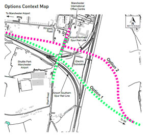
There are two options for a new junction on the scheme with Styal Road. The two junction options are proposed to intersect with Styal Road and cross the rail lines at different points.
This results in a different alignment for the scheme for the two options. The indicative alignments are shown on the Options Context Maps below;
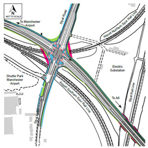
Option 1 – Traffic lights controlled cross roads over airport spur rail lines.
The scheme has a junction with Styal Road, controlled by traffic lights. The existing bridge over the railway lines is widened to accommodate the wider road.
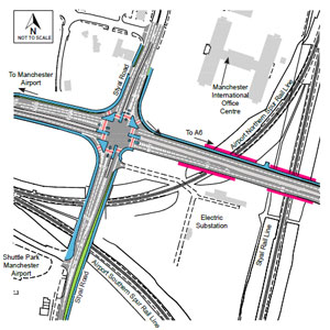
Option 2 – Traffic lights controlled cross roads to the north of the airport spur rail line.
The scheme has a junction with Styal Road, controlled by traffic lights.
The existing bridge over the railway lines is utilised although an additional bridge over the airport spur rail line would be required.
Option Differences
Option 1
- Requires less land
- Requires widening of existing bridge over the railway lines, and
- Has a lower construction cost
Option 2
- Requires an additional bridge over airport spur rail line
- Requires the use of more land than Option 1
- Is simpler to construct than Option1
- Has a higher construction cost, and
- Has greater environmental impact in relation to nature conservation due to loss of locally – significant area of woodland
Further Information
Further technical drawings and road height plans for these junction options are included as pdf documents below:
Technical drawing
- Technical drawing A34 Stanley Road, Stanley Green – Option 1 (PDF 1.10mb)
- Technical drawing A34 Stanley Road, Stanley Green – Option 2 (PDF 1.07mb)
Road height plans
2. A34 / Stanley Road, Stanley Green
There are two options for upgrading the existing A34/Stanley Road junction.
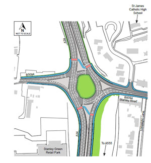
Option 1 – Upgraded roundabout with traffic lights
A four arm roundabout joins the A34 and Stanley Road, controlled by traffic lights. Pedestrians and cyclists would be able to cross the A34 in stages using the controlled crossings.
This option has two crossing points for pedestrian and cyclists making it a simpler crossing movement.
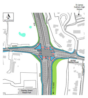
Option 2 – New cross roads with traffic lights
The A34 has a junction with Stanley Road, controlled by traffic lights and has four arms. Pedestrians and cyclists would be able to cross the A34 in stages using controlled crossings.
This option has more crossing stages for pedestrian and cyclists, making it more complex to cross.
Option Differences
Option 1
- Takes the form of a roundabout junction controlled with traffic lights
- Is simpler for pedestrians and cyclists to cross than Option 2 and
- Requires the use of more land than Option 2
Option 2
- Takes the form of a cross road junction controlled with traffic lights
- Is more complex for pedestrians and cyclists to cross than Option 1, and
- Requires the use of less land than Option 1.
Further Information
Further technical drawings and road height plans for these junction options are included as pdf documents below:
Technical drawings
- Technical drawing A34 Stanley Road, Stanley Green – Option 1 (PDF 1.10mb)
- Technical drawing A34 Stanley Road, Stanley Green – Option 2 (PDF 1.07mb)
Road height plans
3. Woodford Road, Bramhall
There are two options for a new junction on the scheme with Woodford Road.
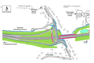
Option 1 – Scheme passes under a realigned Woodford Road with a new traffic lights controlled junction introduced
The scheme passes under Woodford Road which is on two bridges. On Woodford Road traffic heading south will use one bridge. Traffic heading north on Woodford Road, towards Bramhall would use the other bridge.
Slip roads enable traffic to get on and off the scheme to and from the west only. The junctions of the slip roads and Woodford Road would be controlled by traffic lights.
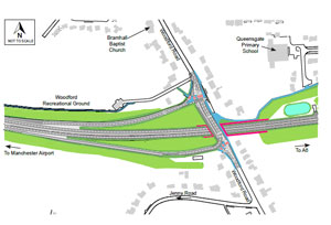
Option 2 – Scheme passes under Woodford Road with new traffic lights controlled junction introduced
The scheme passes under Woodford Road which is on a bridge. Slip roads enable traffic to get on and off the bypass to and from the west only. The junctions of the slip roads and Woodford Road would be controlled by traffic lights.
Option Differences
Option 1
- Requires construction of two bridges
- Requires greater realignment of Woodford Road
- Would take a longer time to construct
- Has the highest construction cost, and
- Results in greater environmental impact in relation to landscape and townscape due to increased views of the road
Option 2
- Requires construction of one bridge
- Makes vehicle manoeuvres in and out of residential properties more difficult when trying to cross three lanes
- Would take the shorter time to construct, and
- Has a lower construction cost
Further Information
Further technical drawings and road height plans for these junction options are included as pdf documents below:
Technical drawing
- Technical drawing Woodford Road, Bramhall – Option 1 (PDF 1.18mb)
- Technical drawing Woodford Road, Bramhall – Option 2 (PDF 1.14mb)
Road height plans
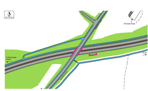
4. Chester Link Road, Poynton
There are two options for a new junction on the scheme with Chester Road.
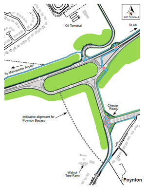
Option 1- Scheme connects to Chester Road via a new short link road.
The scheme has a large traffic lights controlled roundabout junction.
The scheme has a large roundabout junction with the new link road and the Oil Terminal Access Road, which is controlled by traffic lights.
The new link road, from the scheme, forms a junction with Chester Road which is set back and controlled by traffic lights.
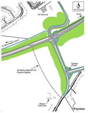
Option 2 – Scheme connects to Chester Road via a new short link road.
The scheme has a traffic lights controlled cross roads junction with a new link road and the Oil Terminal Access Road.
The scheme has a junction with the new link road and the Oil Terminal Access Road, which is controlled by traffic lights.
The new link road has a junction, which is set back and controlled by traffic lights, with Chester Road.
Option Differences
Option 1
- Takes the form of a large roundabout junction controlled by traffic lights
- Requires more land to construct than Option 2 but will have similar land requirements to Option 2 when the Poynton bypass is linked
- Has a higher initial construction cost but reduced disruption when the Poynton Bypass is linked, and
- Has an environmental impact in relation to impacts on Community and Private assets due to larger layout
Option 2
- Takes the form of a crossroad junction controlled by traffic lights
- Requires less initial land but similar to Option 1 when the Poynton Bypass is linked, and
- Has a lower construction cost but will result in disruption when the Poynton Bypass is linked
The Poynton Bypass is not part of the A6 to Manchester Airport Relief Road proposal. The design of the A6 to Manchester Airport Relief Road will enable the proposed Poynton Bypass to be developed by Cheshire East Council in the future.
Further Information
Further technical drawings and road height plans for these junction options are included as pdf documents below:
Technical drawings
- Technical drawing Chester Road Link, Poynton – Option 1 (PDF 98kb)
- Technical drawing Chester Road Link, Poynton – Option 2 (PDF 1.18mb)
Road height plans
5. Woodford Road, Poynton
There are two options for arrangements with Woodford Road and the scheme.
Option 1 – Scheme passes under a new bridge for Woodford Road
The scheme passes under Woodford Road which is on a bridge. Traffic cannot join the scheme at this junction but northbound traffic would be able to join the scheme using the junction at Chester Road.
Southbound traffic would be able to join the scheme at the Macclesfield Road junction.
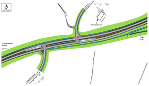
Option 2 – Woodford Road connects to the scheme via two lights controlled, staggered T-junctions
The scheme has two staggered T- junctions with Woodford Road. A junction to head north on Woodford Road, with a second to head south on Woodford Road from the scheme, both of which are controlled by traffic lights.
Traffic heading north and south on Woodford Road would have to join the scheme in order to progress along Woodford Road. Pedestrians and cyclists would be able to cross the scheme using controlled crossings at each junction.
Option Differences
Option 1
- Keeps Woodford Road open by providing a bridge over the proposed road, which pedestrians, cyclists and horseriders could also use
- Has a higher construction costDoes not include a junction with Woodford Road, therefore does not disrupt the flow of traffic on the scheme but reduces access to the scheme from Woodford Road
- Requires the use of more land therefore it has the greatest disuption to existing trees and hedgerows, and
- Reduces likelihood of traffic collisions due to no junction present
Option 2
- Maintains the Woodford Road connection via a new junction, which pedestrians, cyclists and horseriders could also use
- Has a lower construction cost
- Requires adding two junctions to the scheme which could increase delay to travelling along the proposed roadIncrease the potential for a higher rate of traffic collisions, and
- Requires the scheme to be close to existing ground level so is potentially more visible than Option 2
Further Information
Further technical drawings and road height plans for these junction options are included as pdf documents below:
Technical drawing
- Technical drawing Woodford Road, Poynton – Option 1 (PDF 1.17mb)
- Technical drawing Woodford Road, Poynton – Option 2 (PDF 1.08mb)
Road height plans
6. Macclesfield Road, Hazel Grove
There are two options for a new junction on the scheme with Macclesfield Road.

Option 1 – Traffic lights controlled crossroads
The scheme has a junction with Macclesfield Road, controlled by traffic lights. The scheme would be more visible for local residents but would provide less disruption due to shorter construction time.
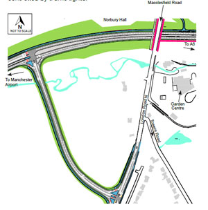
Option 2 – Link road connection between Macclesfield and the scheme
The scheme passes under Macclesfield Road which is on a bridge. A new link road, with a shared cycleway/footpath, will connect the scheme to London Road South.
The new link road will have junctions on either side controlled by traffic lights.
Option Differences
Option 1
- Is a large junction but is focused in one location
- Is the simpler option to construct reducing construction time
- Has a greater visual impact, and
- Has a lower construction cost
Option 2
- Has a junction that requires construction of a link road, increasing the amount of land required
- Is located away from a larger residential area and business properties but introduces an additional junction
- Has less visual impact
- Has the highest construction cost
- Has greater impact on the landscape and ecology due to the link road crossing Norbury Brook, and
- Crosses and impacts on Ladybrook Valley Trail
Further Information
Further technical drawings and road height plans for these junction options are included as pdf documents below:
Technical Drawings
- Technical drawing Macclesfield Road, Hazel Grove – Option 1 (PDF 1.66mb)
- Technical drawing Macclesfield Road, Hazel Grove – Option 2 (PDF 1.85mb)
Road Height Plans